Friday, July 10, 2009
Thursday, July 9, 2009
How to geotag your photos
Geotagging is a great way to know exactly where your photos were taken - and don't you just hate it when you run across an old photo and you haven't a clue?
OK, maybe you are not as obsessive about such things like I am but here's how to geotag most of your GYE photos if you don't have a camera that will do it automatically:
Note that your pictures will be accurately geotagged only if you were near me (i.e., the GPS unit) when you took the photo.
If you want to see the tracks, use the file linked to here.
Best of luck and please contact me if you have any problems or questions!
Dr. C.
OK, maybe you are not as obsessive about such things like I am but here's how to geotag most of your GYE photos if you don't have a camera that will do it automatically:
- Download and install the program GPicsSync on your PC (or install it on the Windows side of an Intel-based Mac running Parallels or Bootcamp); you can install a version in OS X, but for at least for now it is complicated.
- Download and save this gpx file which contains all of the GPS track points I recorded during our hikes, etc. I'm missing a few things (the Granite Canyon record for example), but almost all of the rest of the course events are there.
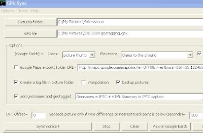
- Run GPicSync; you should get this:

- In the "Pictures Folder" box at the top, indicate the location of your photos (click the Pictures Folder button to browse).
- Likewise, in the "GPS" box, put the location of the gpx file you downloaded (see above).
- In the "UTC Offset" box towards the bottom, put "0" if you've set your camera to UTC (Greenwich mean time); if you left your camera on PDT time, enter "-7"; if you used local Wyoming time (MDT), enter "-6" (note: your camera time must be accurate to within a couple of minutes for any of this to work!).
- The other boxes can be ignored.
- Click "Syncronize" and the program should add latitude and longitude information to each of your photos.
- GPicSync also generates a file, "doc.kml", found in the folder where your photos are, that will allow you to see your results in Google Earth, though any program that can read the geotags will indicate where the photos have been taken; see this GYE photo in Picasa for example.
Note that your pictures will be accurately geotagged only if you were near me (i.e., the GPS unit) when you took the photo.
If you want to see the tracks, use the file linked to here.
Best of luck and please contact me if you have any problems or questions!
Dr. C.
GYE 2009 map for use in Google Earth etc.
Here is a gpx map file of the course that can be run in various mapping programs including Google Earth. The file shows GPS tracks of all our hikes and canoeing as well as the Mammoth and Lamar Valley road trips. A great way to put it all in perspective!
Subscribe to:
Posts (Atom)

